RammSanderson was commissioned by Severn Trent Water to highlight potential ecological constraints and opportunities for a proposed flood alleviation scheme within Scunthorpe via desk-based remote sensing.
The key objective of this project was to outline areas of greatest ecological constraint to the proposed scheme to reduce the scope required for initial ecology surveys.
RammSanderson Approach
Our approach involved combining multiple layers of spatial data using Geographic Information Systems (GIS). Our GIS team obtained habitat data from the UKCEH Land Cover Map (2021) and DEFRA National LIDAR Programme (2021), designated site data from DEFRA and Natural England open publications on data.gov.uk (2023) and species data within 2km of Scunthorpe from Lincolnshire Environmental Records Centre. Linear features, including watercourses, hedgerows and tree lines, were manually digitized from satellite imagery.
Each habitat, designated site and species were assigned rank and weighting considering the legislation and policy that ‘protects’ the feature, how rare it is, how difficult the feature is to mitigate or compensate for, and how the feature can affect a programme of works.
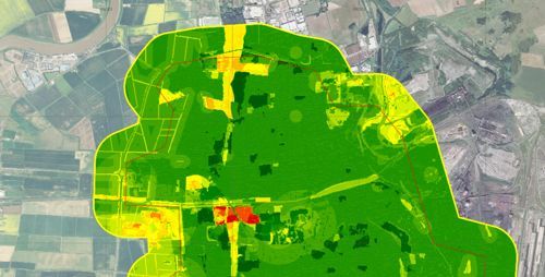
The datasets were then combined to produce a risk surface, with a continuous scale from green through yellow to red, where green represented areas of least combinations of ‘risk’ and red represented areas of greatest combinations of ‘risk’.
Areas with the greatest risk represent combinations of several high-rank and weight ecological features overlapping, for example, a patch of ancient woodland, a cluster of protected species records and a designated site.
This project also highlighted which habitat areas should be retained and enhanced to meet the National Planning Policy Framework and local development plan requirements for biodiversity net gain.
RammSanderson has a team of experienced consultants ready to support your project. Visit our Preliminary Ecological Appraisals page to learn more!